


Walking the Map: XR, Firefighters, and the Future of Emergency Response
Why This Technology Matters Now - An Interview With Rene Peters, Jr, at NVIDIA XR

If we’ve learned anything about weather in recent years, it is that storms and wild fires are becoming increasingly intense with our changing climate. The ability to plan and respond to natural disasters is more urgent now than ever.
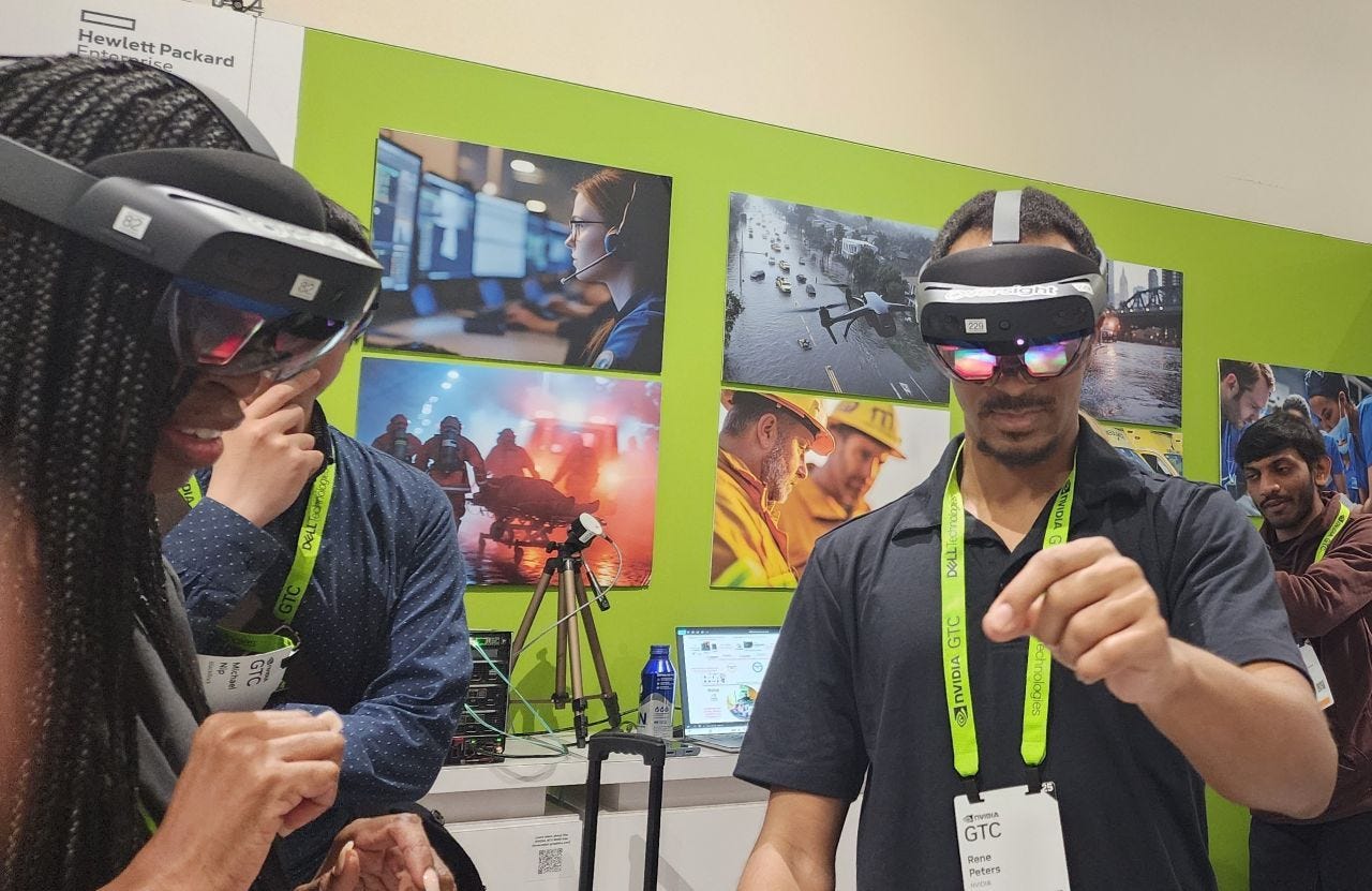
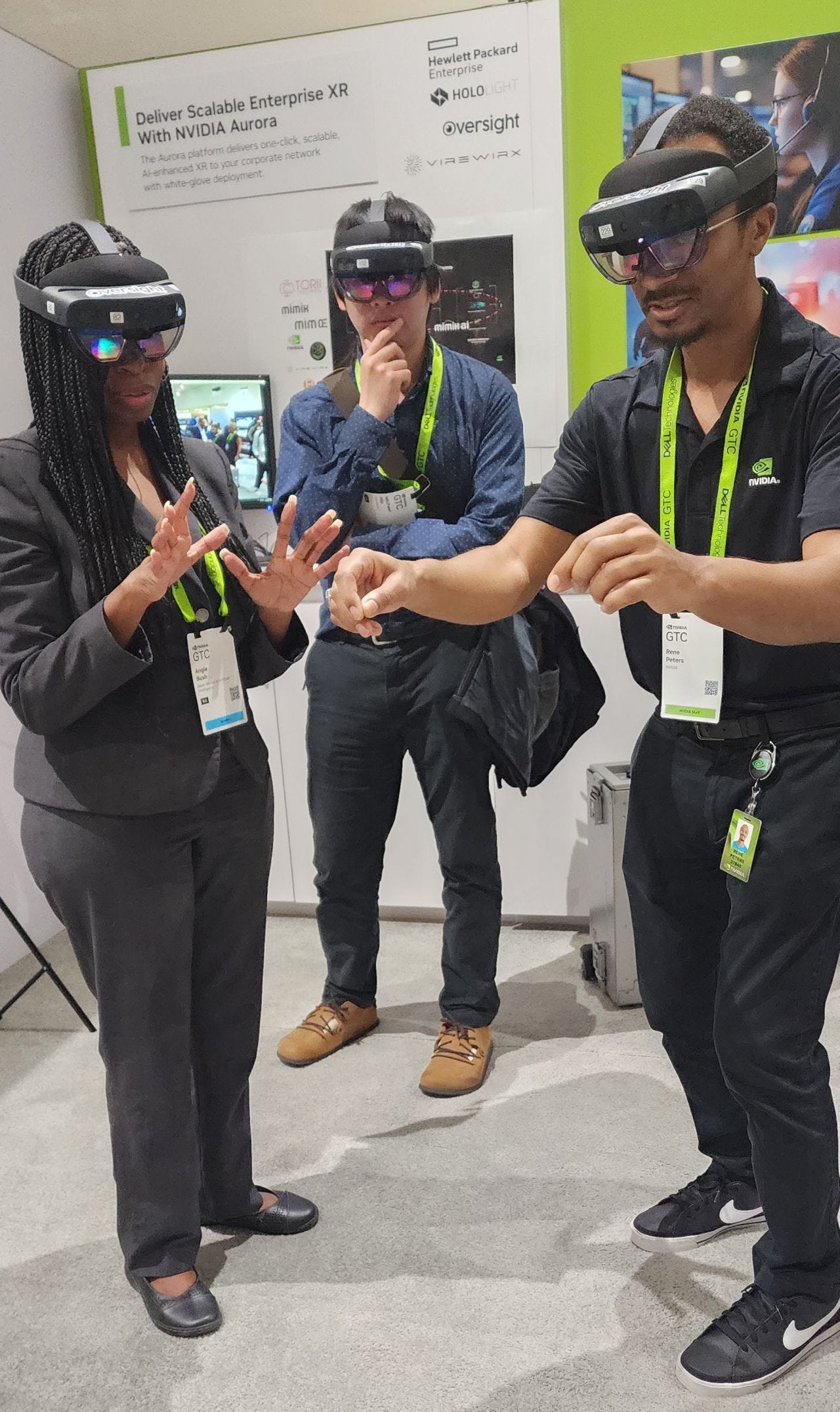
In the middle of a bustling tech conference, I found myself inside a city grid — not looking at it from above, but moving through it at eye level. Street corners, alleyways, and emergency routes stretched around me. It wasn’t a simulation I watched. It was one I stepped into.
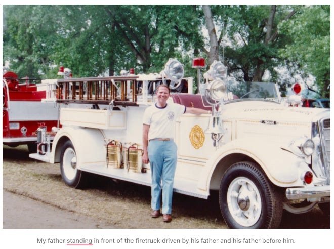
This particular demo caught my eye the moment I saw the images of first responders- in particular, the firefighters. My father was a volunteer firefighter in a small New York town — the kind who kept his Plectron by the bed, volume maxed, much to the rest of the family's consternation. When an emergency call came in, it woke the entire house. But my dad never hesitated. He always got up when that Plectron wailed, and headed toward the location of the fire, or the car accident, or wherever it was the local firefighters were needed that night. No matter how long it took, my dad stayed to finish the job, even if it meant showing up to work exhausted the next day.
Having grown up in that culture — with the blaring radio receiver, the ever-ready boots and flameproof coat, and the silent understanding that duty could call at any moment — it’s no wonder this demo stood out to me. Anything that helps first responders move faster, safer, and smarter always makes me look twice.
At NVIDIA’s GTC 2025, that “look twice” moment became a memorable demonstration of fully immersive command center technology for emergency planning. Not just visualizing emergencies — but walking through them ahead of time, with precision and purpose. I also had a chance to interview Rene Peters Jr., Product Manager of XR, from NVIDIA.
In our conversation, Peters explained how NVIDIA’s XR platform uses real-time data and spatial computing to help first responders plan and adapt on the fly. From optimizing vehicle routes to visualizing what a firefighter sees on the ground, the goal is to turn emergency response into something immersive, collaborative, and fast.
A Marathon, a City Grid, and a Challenge of Access
"The use case that you're seeing behind me is based on emergency response optimization," Peters began. "For example, at the New York Marathon... it's a safety risk for emergency vehicles that have to now navigate that grid."
This specific scenario — a large-scale event in a dense urban area — served as the design brief for NVIDIA’s demo. Equipped with AR devices like HoloLens, emergency planners could visualize a slice of the city in 3D, overlaid with real-time data from IoT sensors, GIS, and satellite feeds.
A small silver device, the Fuse Core, sat on a nearby shelf. In deployment, it would be installed in ambulances, fire trucks, or police vehicles, continuously transmitting location and, in some cases, video data.
That live data, when combined with satellite and GIS layers, forms the backbone of a volumetric rendering of the city grid in real time — not just a map, but an interactive, multi-perspective command simulation.
Supercomputers and Sightlines: The Architecture of Immersive Planning
"We have HPE — another one of our technology partners — that has a supercomputer, which you can think of as a real-time decision-making engine," Peters explained.
This engine enables planners and responders to simulate emergencies before they unfold. It supports features like:
Dynamic routing: Optimize vehicle paths as the crisis evolves.
Perspective views: See the city from the viewpoint of a fire truck, a patrol officer, or an aerial drone.
Live stream overlays: Integrate what responders are seeing on the ground, in real time, into the AR environment.
Sightline mapping: Ensure safety posts at live events have visual coverage ahead of time.
"We can find live streams of what their viewshed is — meaning their line of sight... You can anticipate those ahead of time."
What emerges is a command post that thinks spatially. And because it’s wearable and collaborative, it becomes a space for shared cognition — a planning environment as dynamic as the city it simulates.
From Wildfires to What-Ifs: Before the Emergency Strikes
I asked how this might apply to large-scale disasters — like the recent Los Angeles wildfires — Peters shifted the frame from real-time response to real-time readiness.
"You're asking about during the emergency, but it's also important to think about before the emergency," he said.
This tool isn’t just about reacting faster — it’s about predicting smarter. Satellite imagery can highlight environmental risks like dry vegetation zones, which can then be cross-referenced with building types and locations. The result: a risk map that’s not only visual but actionable.
"It’s all about seeing the risk and anticipating the emergency response times ahead of time. How do we get to those risk areas in a more optimal fashion?"
What Happens When the Worst Does Come
"So you could use this tool before and during an emergency,"
City planning
Event logistics
Disaster preparedness
Public safety coordination
Industrial and infrastructure resilience
Walking Through Crisis, Together
The power of this system isn’t just in the graphics or compute — it’s in the collaboration. I saw that firsthand during the demo. Two users, wearing headsets, exploring the same environment. We could manipulate different map layers, expand views, and navigate potential response routes together.
For anyone involved in detailed city planning or safety coordination, the implications are massive. Teams don’t have to just talk about contingency plans. They can walk through them, spatially, before ever stepping into the field.
I write about AI, robotics, and autonomous vehicles. Join the WolfPack by following my free newsletter here on LinkedIn, or over on Substack. You can also find me on YouTube, Spotify, and Apple Podcasts.
Vocabulary Key
Plectron: a dispatch device for fireghters, used in the 1970s
Volumetric Rendering: 3D reconstruction of real-world spaces from satellite, video, or LIDAR data.
Viewshed Analysis: A technique to determine what is visible from a specific location — used for surveillance or planning.
IoT (Internet of Things): Connected sensors and devices transmitting real-time data, such as vehicle location or environmental conditions.
Fuse Core Device: A small IoT module designed to be embedded in emergency vehicles for telemetry and video streaming.
FAQs
What’s the core innovation here? Spatially aware, multi-user XR command posts that visualize and optimize real-time emergency response.
Is this related to NVIDIA Earth-2? They are complementary. Earth-2 forecasts climate trends. This system supports operational crisis response.
What role do supercomputers play? They enable real-time decision-making by processing massive data streams from IoT and satellite inputs.
Can this be used outside of emergencies? Absolutely — for event planning, city infrastructure visualization, or industrial safety walkthroughs.
Who are the key partners? NVIDIA, HPE, Oversight AR, Hololight, Diwo, GRID Factory, and others in the XR and AI ecosystems.
#xr #emergencyresponse #spatialai #nvidia #supercomputing #gtc #xr #smartcities #emergencymanagement #ar #urbanplanning #hpc #ai #disastertech #deeplearningwiththewolf #nvidiagtc2025 nvidiaxr